
Earthquakes in Uttarakhand and the Growing Instability of Himalayan Slopes

The Himalayas, among the world’s youngest and most fragile mountain systems, make Uttarakhand highly vulnerable to earthquakes and landslides. A moderate tremor on 6 October 2026 and a reported landslide near Gairsain that temporarily blocked a stream highlight these risks. While earthquakes cannot be predicted, scientific awareness, earthquake-resistant construction, proper land-use planning and proactive disaster management can greatly reduce damage. Unregulated construction on unstable slopes worsens vulnerability. Effective response requires timely field assessments, continuous monitoring and respect for geological limits. Development must integrate scientific caution so that mountain communities can live safely within this dynamic landscape.
Earthquakes and Unstable Mountain Slopes: A Geologist’s Warning to Uttarakhand

-Prof (Dr.) Mahendra Pratap Singh Bisht
The Himalayas are among the youngest, most dynamic and geologically fragile mountain systems in the world. Uttarakhand, situated in the central Himalayan region, is particularly vulnerable to earthquakes, landslides and other natural hazards. The increasing instability of mountain slopes, coupled with unregulated construction and inadequate attention to geological conditions, has made this vulnerability a matter of serious public concern.
To understand the nature of earthquakes, we must first appreciate the internal structure of the Earth. Its outermost solid layer, known as the crust, varies considerably in thickness. Beneath the continents, it averages approximately 35 kilometres, although it can be substantially thicker beneath major mountain ranges such as the Himalayas. Below the crust lies the mantle, extending to a depth of about 2,900 kilometres.
Contrary to a common misconception, the mantle is predominantly solid, although its rocks can deform slowly under enormous pressure and temperature. Most tectonic earthquakes occur when accumulated stress along faults within the Earth’s crust or uppermost mantle is suddenly released. This release generates seismic waves that travel through the Earth and produce the shaking experienced at the surface.
The underground point where an earthquake rupture begins is called the hypocentre or focus, while the point directly above it on the Earth’s surface is known as the epicentre. The severity of damage depends not only on the earthquake’s magnitude but also on its depth, distance from the rupture, local geological conditions and the vulnerability of buildings and infrastructure.
The Earthquake of October 6, 2026: A Reminder of Himalayan Vulnerability
On the night of October 6, 2026, at approximately 10:23 p.m., earthquake tremors were reportedly felt in parts of Uttarakhand. Soon afterwards, telephones began ringing. I received numerous calls from friends, former students and journalist colleagues, all seeking answers to similar questions.
What caused the earthquake? How much damage might it have caused? Could stronger tremors follow? Can we predict when the next earthquake will strike?
I tried to explain the geological processes in simple language. Some callers were interested in the scientific mechanisms, while others were understandably concerned about the possibility of a major disaster.
One conclusion emerged from these conversations: despite remarkable advances in seismology, scientists still cannot reliably predict the exact time, location and magnitude of an earthquake. However, our inability to predict earthquakes does not mean that we are helpless against their consequences.
Scientific awareness, earthquake-resistant construction, proper land-use planning and effective disaster preparedness can substantially reduce the loss of human life and property.
Those who witnessed the devastating Uttarkashi earthquake of 1991 and the Chamoli earthquake of 1999 understand the destructive potential of Himalayan seismic activity. These disasters remain painful reminders of the vulnerability of mountain settlements.
Even a moderate earthquake can cause serious damage where buildings are structurally weak or slopes are already unstable. Conversely, well-engineered structures and appropriate preparedness can significantly reduce damage during stronger earthquakes.
A Disturbing Report from Gairsain
My concern deepened when one of my former students, Kailash Sati, contacted me from Gairsain with disturbing information.
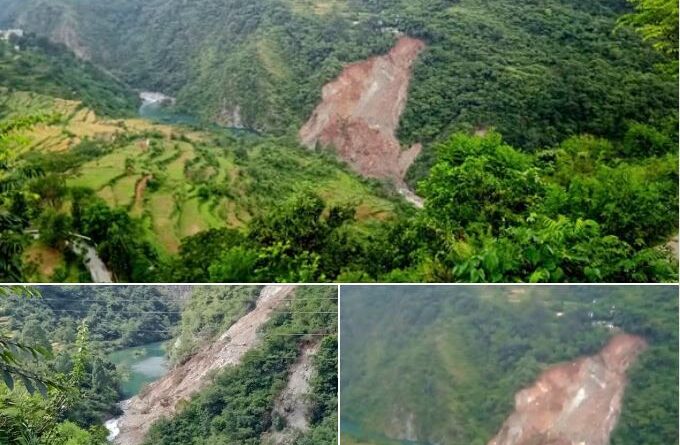
According to his account, a landslide had occurred near Simalt village, along the left bank of the Ata Gad stream, approximately eight to ten kilometres from Shimli on the road towards Gairsain in Chamoli district.
He reported that landslide debris had obstructed the natural flow of the stream, leading to the formation of a temporary lake upstream. Local residents were reportedly alarmed and had circulated videos appealing to the authorities for immediate intervention.
If these reports are confirmed, the situation deserves urgent attention.
A landslide-dammed lake can become dangerous when accumulated water exerts pressure on an unstable debris barrier. If the obstruction suddenly fails, the resulting flood surge may threaten settlements, roads, bridges and agricultural land downstream.
Such situations require immediate field assessment by qualified geologists and disaster management specialists, continuous monitoring of water levels and appropriate precautionary measures for potentially affected communities.
It is also important to establish whether the reported slope failure was directly associated with the earthquake or resulted from other factors, such as rainfall, weathering, existing geological weaknesses or human interference. A temporal coincidence alone cannot establish a causal relationship.
The larger question, however, remains: how promptly do our institutions respond when people living in remote mountain villages report emerging geological hazards?
Disaster Management Must Go Beyond Institutional Arrangements
Over the years, an extensive disaster management structure has been established, extending from the national and state levels to districts and local communities.
Numerous departments, authorities, technical institutions, consultants and emergency response teams are involved in disaster preparedness and management. Considerable public resources are devoted to these arrangements.
Yet the effectiveness of such a system cannot be judged merely by the number of institutions, officials, consultants or plans. Its real test lies in how quickly and effectively it identifies hazards, communicates warnings and protects vulnerable communities.
People living in remote Himalayan villages should not have to wait for a major disaster before their concerns receive official attention.
Across Chamoli, Pithoragarh, Bageshwar, Rudraprayag and Uttarkashi districts, numerous settlements face varying degrees of exposure to landslides, slope instability, erosion and seismic hazards.
Some villages are located on old landslide deposits, while others occupy steep slopes, unstable geological formations or areas affected by active erosion. Many settlements also face additional risks from changing rainfall patterns and poorly planned infrastructure development.
These conditions demand systematic geological investigations, updated hazard maps, regular slope monitoring and scientifically informed decisions on construction and settlement safety.
Where risks cannot be adequately reduced through engineering or other protective measures, planned relocation may become necessary.
Disaster management should be preventive rather than merely reactive.
Unregulated Construction Is Increasing Mountain Vulnerability
As a geologist, I have repeatedly tried to draw public attention to the fragile nature of the Himalayan environment through my writings and social media interactions.
Unfortunately, geological warnings are often ignored until a disaster occurs.
The rapid expansion of roads, hotels, resorts, residential complexes and other infrastructure across vulnerable mountain slopes has raised serious concerns.
Construction on steep terrain is not inherently unsafe, but development undertaken without proper geological investigation, slope-stability assessment, drainage planning and appropriate engineering safeguards can substantially increase the risk of failure.
Indiscriminate hill cutting, poorly managed excavation debris, obstruction of natural drainage channels and excessive loading of unstable slopes can further aggravate existing geological weaknesses.
Economic development is necessary for the Himalayan region. Tourism, roads, employment and modern facilities are essential to improving the quality of life of mountain communities.
However, development that disregards the geological limitations of the terrain may ultimately undermine the very communities it is intended to benefit.
The Himalayas cannot be treated as ordinary construction sites. Their geological history, active tectonics, steep slopes and complex hydrological systems demand a different approach to planning.
The Need for Scientific Responsibility and Public Awareness
One of the most troubling aspects of the present situation is the tendency to regard geological warnings as unnecessary alarm.
When experts advise caution regarding construction on unstable slopes or the obstruction of natural drainage systems, their recommendations are sometimes dismissed as obstacles to development.
But geological processes do not respond to administrative convenience or commercial interests.
A mountain slope does not become stable merely because a building permit has been issued. Nor does an active fault become harmless because a settlement has existed above it for generations.
Scientific assessments must therefore become an integral part of development planning.
Local communities also have an important role to play. Residents often possess valuable knowledge about old landslides, ground cracks, changes in spring discharge, unusual slope movements and the behaviour of mountain streams.
Such observations should be documented and incorporated into local hazard assessments.
At the same time, people must understand the importance of earthquake-resistant buildings, emergency evacuation plans and basic disaster preparedness.
Public awareness should not be limited to occasional campaigns. It must become a continuing part of education and community life.
A Warning That Must Not Be Ignored
The Himalayas are living mountains, constantly responding to tectonic forces, erosion, climatic variations and human activities.
Earthquakes are natural geological events that cannot be prevented. Landslides, too, are part of the natural evolution of mountain landscapes. However, the scale of destruction they cause is often influenced by human decisions.
We cannot control the movement of tectonic plates, but we can control where and how we build. We cannot stop intense rainfall, but we can protect natural drainage systems and avoid destabilising vulnerable slopes.
Above all, we can ensure that scientific warnings are taken seriously and that disaster management institutions remain accountable to the communities they are meant to protect.
My concern is not merely about the next earthquake. It is about the growing vulnerability of our mountains and the apparent reluctance to recognise the consequences of irresponsible development.
During this sacred period of remembrance of our ancestors, I consider it my moral responsibility to share these concerns and remind society of its duty towards future generations.
Our ancestors lived with the mountains, respected their natural limitations and understood the importance of maintaining a balance with their surroundings. Modern science has given us far greater knowledge of geological hazards. We must now demonstrate the wisdom to apply that knowledge.
The Himalayas will continue to move, rivers will continue to erode their valleys, and mountain slopes will continue to evolve. The question is whether we will learn to live responsibly within this dynamic environment.
There is still time to act. But scientific warnings must be translated into practical measures before another disaster reminds us of the cost of neglect.
Jai Hind.
=================================================================================
ABOUT AUTHOR : Professor Mahendra Pratap Singh Bisht is a renowned geologist and academician associated with Hemvati Nandan Bahuguna Garhwal University. A former Director of the Uttarakhand Space Application Centre, he has extensive expertise in Himalayan geology, geohazards, environmental studies and disaster management. This is an edited English adaptation of the author’s original Hindi social media article. The geological explanations have been refined for scientific accuracy.